3291 - Pylon Peak Track
Pylon Peak Track
There are several options here, so decisions will be made closer to the time and dependent on weather.
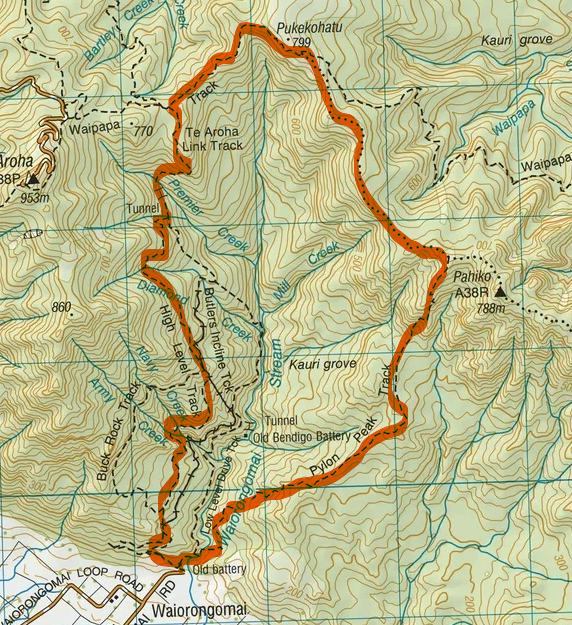
We will head up Pylon Peak Track from the Wairongomai carpark. The Wairongomai River must be crossed at the start of the track so be prepared for wet feet or putting shoes on after this crossing. Another option is that we change direction, so this is required at the end.
Based on an anti-clockwise tramp. After the initial climb, the incline lessens for about 1500m and then steepens considerably for the ascent to the crest of the Kaimai Range. There are extensive views over the Waikato. Te Aroha can be spotted to the northwest. Following the trail for a few more metres the track leads to a rocky outcrop known as Pylon Peak and the junction with North South track.
We the take the left track northwest towards Pukekohatu, following the ridgeline for about 300m over a broad saddle. The 100m climb to Pukekohatu (799m) then begins. The trail passes over hanging bridges and even goes through a short mining tunnel.
There are a few options to head back to the car park. This is a particularly relaxing route and passes through regenerating bush for the last hour. There are waterfalls and more remains of the golden (mining) past. Looking to the left side of the trail, occasional views into the Wairongomai Valley will help you realise that you’ve come a long way. Up and down and all around.
Approx 12-13kms / 6-7 hours. Rating M
| Leader: | Alicia Carthew | Phone: | 027792331 | |
| Grade: | M | Email: |
|
|
| Transport (van): |
|
|||
Event Information
| Event Date | Sat 17th Apr 2027 |
| Event End Date | Sat 17th Apr 2027 |
| Capacity | Unlimited |
| Registered | 0 |